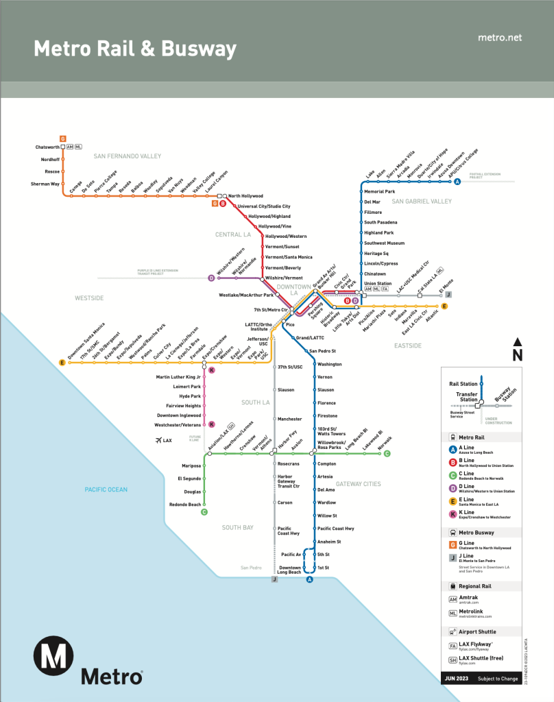
Three rail lines have become two rail lines in Los Angeles, providing one-seat rides from four corners of Los Angeles County.

The Los Angeles County Metropolitan Transportation Authority (Metro) opened the long-awaited Regional Connector to the public on June 16, completely redrawing Metro’s rail service map in the process.
“The 1.9 miles of new track laid allows light-rail trains to travel between Union Station and the busy 7th St./Metro Center Station in downtown LA’s Financial District,” according to an article by Brandon Lewis for Mass Transit magazine. “Bridging the gap allows L.A. Metro to merge the hook-shaped L (Gold) line with the A (Blue) and E (Expo) lines, creating two serpent-like train lines where there were once three.”
In effect, the two newly formed lines allow one-seat light rail rides from Azusa to Long Beach on the A Line, and East L.A. to Santa Monica on the E Line. The project overcame delays in 2019 and a lawsuit in 2012 to come to fruition.
The new project also delivered three new underground stations to serve the newly formed A and B lines in downtown—the Little Tokyo/Arts District Station, the Historic Broadway Station, and the Grand Avenue/Bunker Hill Station.
Local coverage of the Regional Connector’s contribution to transit in Los Angeles is available from L.A. Taco and the Los Angeles Times [paywall]. See also Metro’s Regional Connector Transit Project page for more information.

FULL STORY: L.A. Metro celebrates opening of Regional Connector

‘Forward Together’ Bus System Redesign Rolling Out in Portland
Portland is redesigning its bus system to respond to the changing patterns of the post-pandemic world—with twin goals of increasing ridership and improving equity.

Plan to Potentially Remove Downtown Milwaukee’s Interstate Faces Public Scrutiny
The public is weighing in on a suite of options for repairing, replacing, or removing Interstate 794 in downtown Milwaukee.

Can New York City Go Green Without Renewable Rikers?
New York City’s bold proposal to close the jail on Rikers Island and replace it with green infrastructure is in jeopardy. Will this compromise the city’s ambitious climate goals?

700-Acre Master-Planned Community Planned in Utah
A massive development plan is taking shape for lakefront property in Vineyard, Utah—on the site of a former U.S. Steel Geneva Works facility.

More Cities Ponder the End of Drive-Thrus
Drive-thru fast food restaurants might be a staple of American life, but several U.S. cities are actively considering prohibiting the development of new drive-thrus for the benefit of traffic safety, air quality, and congestion.

Air Pollution World’s Worst Public Health Threat, Report Says
Air pollution is more likely to take years life off the lifespan of the average human than any other external factor, according to a recent report out of the University of Chicago.
Placer County
City of Morganton
HUD's Office of Policy Development and Research
Dongguan Binhaiwan Bay Area Management Committee
City of Waukesha, WI
Los Angeles County Metropolitan Transportation Authority
Indiana Borough
Urban Design for Planners 1: Software Tools
This six-course series explores essential urban design concepts using open source software and equips planners with the tools they need to participate fully in the urban design process.
Planning for Universal Design
Learn the tools for implementing Universal Design in planning regulations.


